


Alabama Hills National Scenic Area
The Alabama Hills are a formation of rounded rocks and eroded hills set between the jagged peaks of the Sierra Nevada and the geologically complex Inyo Mountains. Both geologic features were shaped by the same uplifting occurring 100 million years ago. The hills are located west of Lone Pine and are managed by the Bureau of Land Management.
Visitors enjoy touring film sites, photography, rock climbing, exploring natural arches, and viewing the swaths of wildflowers that bloom every spring. In March 2019, Congress designated the Alabama Hills as a National Scenic Area as a part of the John D. Dingell, Jr Conservation, Management, and Recreation Act.
A Movie Maker’s Paradise
This area has long been used as a film location (think Hop A Long Cassidy, John Wayne, etc.) and is one of the most highly photographed areas in California. Ambling among formations of weathered, golden granite, it’s easy to see why these dry hills and boulders, backed by the snowy Sierra, have attracted movie crews since the film industry’s earliest days. hills and boulders, near the snowy Sierra, have attracted film crews since the earliest days. Check out the Quick Guide to the Alabama Hills National Scenic Area here!
Enjoyable for Everyone
 The rounded contours of the Alabama Hills appear in stark contrast to the chiseled peaks of the Sierra Nevada and, although considered geographically a separate range of hills, they were formed at the same time and are geologically part of the Sierra Nevada Mountains. Percolating water rounded the granite blocks and sculpted the many outstanding formations of the Alabama Hills.
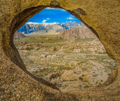
The Mobius Arch, the largest and most picturesquely situated of the many natural arches in the Alabama Hills, almost perfectly frames Mt. Whitney, the highest peak in the contiguous USA. It is the result of chemical weathering when the hills were still covered with soil.
These rock formations offer a playground for those looking to rock climb, scramble, explore, off-road, mountain bike, trail run, camp and more.
Directions, Parking and Regulations
From the heart of Lone Pine (a beautiful 60 minute drive south of Bishop) go west on Whitney Portal road then, 2.7 miles along, turn right onto Movie Flat road. Many dirt roads and trails intersect with Movie Flat road leading into the hills and among the boulders. Movie Flat road is a graded dirt road maintained for passenger vehicles. Other roads may be sandy and soft requiring 4-wheel drive capability.
Vehicle and mountain bike use is restricted to existing roads and trails and dispersed camping must be done in obvious clearances. Don’t crush the brush!
There are no services or facilities on site and the nearest hospital is located in Lone Pine. Remember inclement weather can occur at any time and often rapidly. Be prepared with layers of protective clothing, a hat and sunscreen for the hot and sunny days. Always bring plenty of water with you.
The Alabama Hills National Scenic Area is managed by the U.S. Bureau of Land Management (BLM) and is a protected habitat for public enjoyment. For more information visit the BLM website or stop in at the Bishop Visitor Center, at 690 N. Main St in Bishop, for maps to this and other great local destinations.
Care for the Alabama Hills National Scenic Area
The indigenous people of this valley still reside in this place where their ancestors have lived for thousands of years. They ask that you respect and care for this land. Do not disturb or destroy anything that you may find.
- Pack out all trash. There are no trash services. In the high desert environment, even natural items like orange peels take years to decompose.
- Travel on existing roads and trails. Vegetation in this climate can take decades to recover when crushed by off road driving or parking.
- Camp in campgrounds. Using campgrounds reduces the number of vehicles, so that the great views are not blocked.
- Use the restroom in town or at nearby campgrounds. If that isn’t an option, bury human waste in catholes 6 inches deep and 200 feet away from water, trails and camp. There are no restrooms in the hills.
- Have a great time. The Alabama Hills are a great place to explore natural wonders and experience your public lands.
How They Were Formed
The Alabama Hills are a golden-brown wonderland of rounded hills and twisted rock formations lying between Lone Pine and the Sierra. The Alabamas, once incorrectly touted as “the earth’s oldest hills,” are now known to be the same age as the Sierra, both being formed a “few million years ago” by faulting.
Identical in composition, their difference in appearance comes from different weathering processes. Up high, the freezing, expanding and thawing of rainwater and melting snow has caused the more chiseled splintering of the granite. Down in the warmer valley, the Alabamas took shape when “the climate was more moist and the rock was covered with soil,” according to a recent geologist’s report printed in “California’s Eastern Sierra” by Sue Irwin. As the climate became drier, erosion slowly stripped away the soil mantle, exposing and shaping the piles of boulders we see today. Water and wind continue the shaping process. The beige and blacks in the mottled coloring are the result of being stained for millions of years by the oxidation of the iron minerals in the rock.
How They Were Named
The unusual name Alabama Hills came about during the Civil War. In 1864 Southern sympathizers in Lone Pine discovered gold “in them thar hills.” When they heard that a Confederate cruiser named the Alabama had burned, sunk or captured more than 60 Federal ships in less than two years they named their mining claims after the cruiser o celebrate. Before long the name applied to the whole area. Coincidentally, while Southerners were prospecting around Lone Pine, there were Union sympathizers 15 miles north near Independence. And when the Alabama was sunk off the coast of France by the U.S.S. Kearsarge in 1864, the Independence people struck back. They not only named their mining claims “Kearsarge” but a mountain peak, a mountain pass, and a whole town as well.