


Eastern Sierra
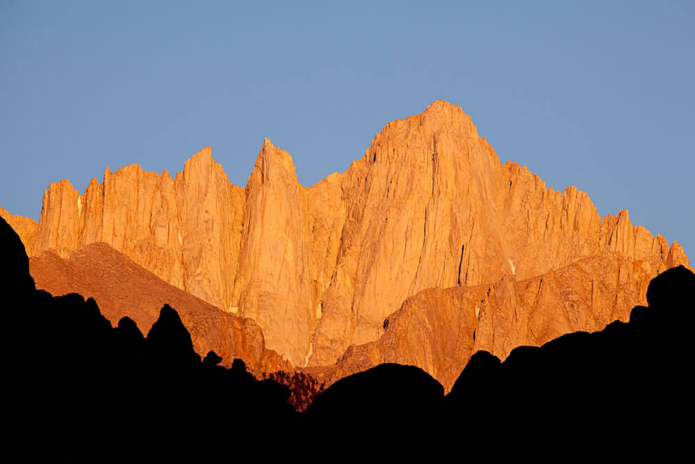
Mount Whitney
On the east side of the Great Western Divide, Mt. Whitney stands 14,496 ft/4,418m, the tallest mountain in the contiguous United States. Hikers reach the summit through Whitney Portal, 13 miles west of Lone Pine. It’s a 10.7 mile hike and requires planning, a wilderness permit and careful attention to advisories regarding the precautions of hiking at high altitudes, obtained within the Eastern Sierra InterAgency Visitor’s Center, south of Lone Pine.
The best viewpoint for seeing Mount Whitney without having to hike is through the Mobius Arch in the Alabama Hills, just west of Lone Pine.
Note: A permit is required to hike Mt. Whitney. To get one, you’ll need to apply through a lottery system, which accepts applications from February 1 through March 15.
Palisade Glacier
The southernmost glacier in the U.S. and the largest in the Sierra Nevada is located west of Big Pine and is visible from U.S. 395. The glacier sits at the base of Palisade Crest in the North Fork Basin. The scenery attracts hikers to trails that follow the ancient glacier.
Bishop Creek Canyon
Southwest of Bishop, the 18-mile drive along Highway 168 into Bishop Creek Canyon is one of the best ways to spot fall colors in the entire state of California. That being said, Bishop Creek is a great side trip no matter the season. Whether you head to North Lake, South Lake, or Lake Sabrina, the road itself is a scenic day trip, but we highly recommend getting out and hiking around to truly experience what the canyon has to offer. If you only have a couple hours, head to Lamarck Lakes from North Lake (about 4.5 miles round-trip to the Lower Lamarck Lake, or 5.8 miles roundtrip to the Upper Lamarck Lake). The lakes are surrounded by sheer cliffs and rugged peaks, and the trail includes some creek crossings and plenty of colorful wildflowers in the early season.
Free Wilderness permits for overnight trips are available from the White Mountain Ranger Station in Bishop. Day hiking does not require a permit, so just get out there and enjoy the trails!
Rock Creek Canyon
Between Bishop and Mammoth Lakes is picture-perfect Rock Creek Canyon. Rugged Eastern Sierra sawtooth peaks rise above emerald meadows, populated with fluttering aspens and cut by meandering clear streams.
The Backcountry
Follow CA-168 west from Bishop, 23 miles to trails that lead to the Green Lakes, Treasure Lakes and Bishop Pass. The pass is an 11-mile hike beyond the end of the road at 11,980 ft/3,651 m. Bring a fishing rod for entertainment along the way.
Treasure Lakes
Sitting below the Sierra Crest and the high peaks of Hurd Peak (12,237′), Mt. Johnson (12,871′), and Mt. Gilbert (13,106′), Treasure Lakes are a series of several lakes starting near the bases of the peaks and flowing down their drainage into the granite basin. The Treasure Lakes trail branches off on the right from the Bishop Pass trail after you climb above South Lake and is clearly signed.
Marie Louise Lakes
Escape the main trail for a short hike to Marie Louise Lakes and discover the serene high lakes named after the wife of the founder of Parchers Resort. Along the way you have views of South Lake and an old sawmill site. The trail branches off from the Bishop Pass trail to the left and is clearly signed.
Bishop Pass
Take the Bishop Pass Trail for a fishing trip to the gorgeous Long Lake, a 6.4 mile day hike around Ruwau and Chocolate Lakes, or for a multi-day backpacking trip over the Sierra Crest into Kings Canyon National Park and to meet up with the John Muir Trail. This stunning lakes basin is encircled by Hurd Peak to the North and the Inconsolable Range to the South, with views of Mt. Goode (13,085′) and Mt. Agassiz (13,893′) at the crest.
And on your way up to South Lake, you will pass many campgrounds and amenities. Stop by before your trip for fishing licenses and bug spray, or afterward to rehydrate and refuel and just plain celebrate your day.
Inyo National Forest and the John Muir Wilderness
For complete retreat, backpack or take a mule pack trip to the high country, to dozens upon dozens of remote glassine lakes with romantic names like Lake Helen of Troy, Elinore Lake, Moonlight Lake and the Treasure Lakes. You will understand why John Muir wrote, “Climb the mountains, and get their good tidings.” Few experiences are as emotionally satiating as being in the rarified air of the Eastern High Sierra in settings whose beauty defy description.
John Muir dedicated his life to protecting the wilderness in the Sierra Nevada. Lucky for us, not much has changed since the days that Mr. Muir himself wandered along the trails through deep canyons and wildflower-filled meadows. The 215-mile John Muir Trail (JMT) is one of the best ways to explore all this wilderness area has to offer, and is a wonderful opportunity to “enjoy every mile, every meal, and every vista” as the locals do. About 100 of these miles wind through the Sierra, with a handful of trailheads within 30 minutes of downtown Bishop. Have your camera ready to capture the views of the 13,000-foot peaks and turquoise-colored alpine lakes as you follow in Muir’s footsteps.
Note: The is the second most-visited wilderness in the United States, so make sure to get your permit for backcountry camping trips.
Sierra Bighorn Sheep
Three subspecies of bighorn sheep live in the United States. You can see two of them within minutes of one another in Inyo County, California. Sierra Bighorn can be seen in Eastern Sierra canyons. From U.S. 395, north of Bishop, follow Pine Creek Road through Round Valley. In the last couple of miles before the road ends, look up to the north to see the buff-colored coats of the Sierra Bighorn Sheep as they graze among pines and brush. You will be surprised how well they blend into the landscape and how difficult it is, at first, to see them. With practice, it becomes easier. There are no formal tours to see the bighorn, though if you call sheep researcher Dr. John Wehausen in advance, (760) 873-4563, you may be able to join one of his infrequent bighorn spotting trips. Additionally, the Bishop office of the California Department of Fish and Game can explain how best to see the elusive bighorns. Some tips: the Bighorn will not let you get closer than a couple of hundred yards, so bring powerful binoculars or a camera with a telephoto lens and enjoy seeing them from a distance.
Trees of the Eastern Sierra
A guide to identifying the following trees is available from: friendsoftheinyo.org
-
- Riparian Areas
- Silver Buffaloberry – sherpeherdia argentea
- Wood Rose – Rosa woodsii
- Poplar Family
- Fremont Cottonwood – Populus fremontii
- Black Cottonwood – Populus balsamifera ssp. trichoparda
- Quaking Aspen – Populus tremuloides
- Willow – Salix spp.
- Birch Family
- Water Birch – Betula occidentalis
- Dogwood Family
- Creek Dogwood – Cornus Sericea
- Cypress Family
- Sierra Juniper – Juniperas occidentalis
- Utah Juniper – Juniperas osteosperma
- Pine Family
- Mountain Hemlock – Tsuga mertensiana
- Red Fir – Abies magnifica
- White Fir – Abie concolor
- Singleleaf Pinyon – Pinus monophylla
- Bristlecone Pine – Pinus longaeva
- Limber Pine – Pinus flexilis
- Whitebark Pine – Pinus albicaulis
- Western White Pine – Pinus monticola
- Jeffrey Pine – Pinus jeffreyi
- Lodgepole Pine – Pinus contorta
- Riparian Areas