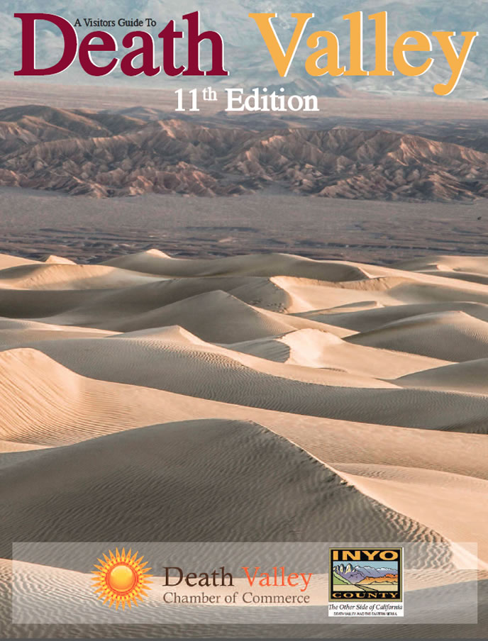
Project Description
Stunning Sights and Scenes in Death Valley
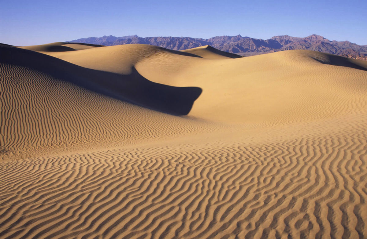
The sprawling Mesquite Sand Dunes, just outside of Stovepipe Wells Village.
Death Valley contains millions of acres of wild and scenic land. Tucked into that sprawling landscape are more than a few truly stunning sights, as outlined below.
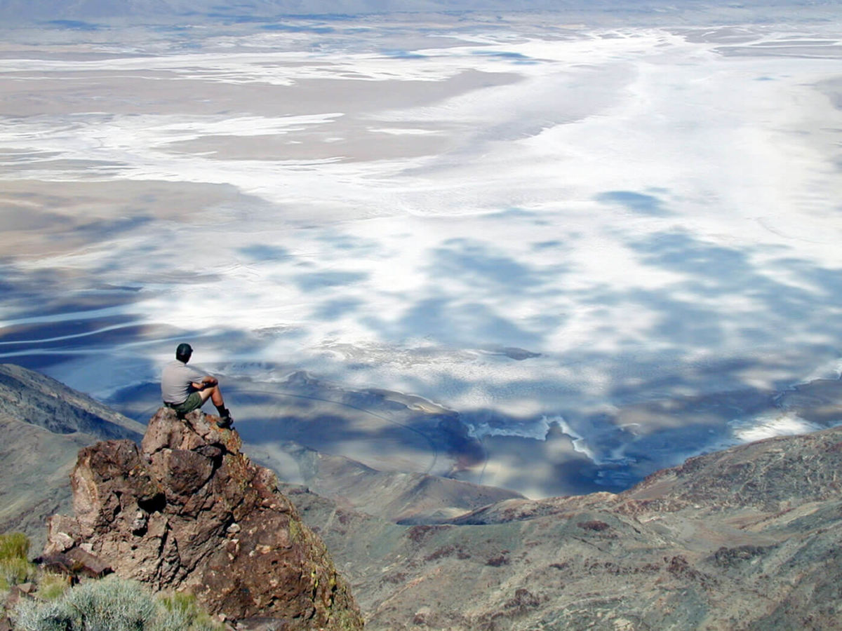
Badwater Basin – Badwater is the site of the lowest place on land in North America, at 282 feet below sea level. The scene is much more than an elevation marker. Seeps create small pools of water that dramatically reflect the nearby black mountains. Telescope Peak, the highest point in Death Valley looms majestically, 11,000 feet above and across the valley. Located 17 miles south of Furnace Creek.
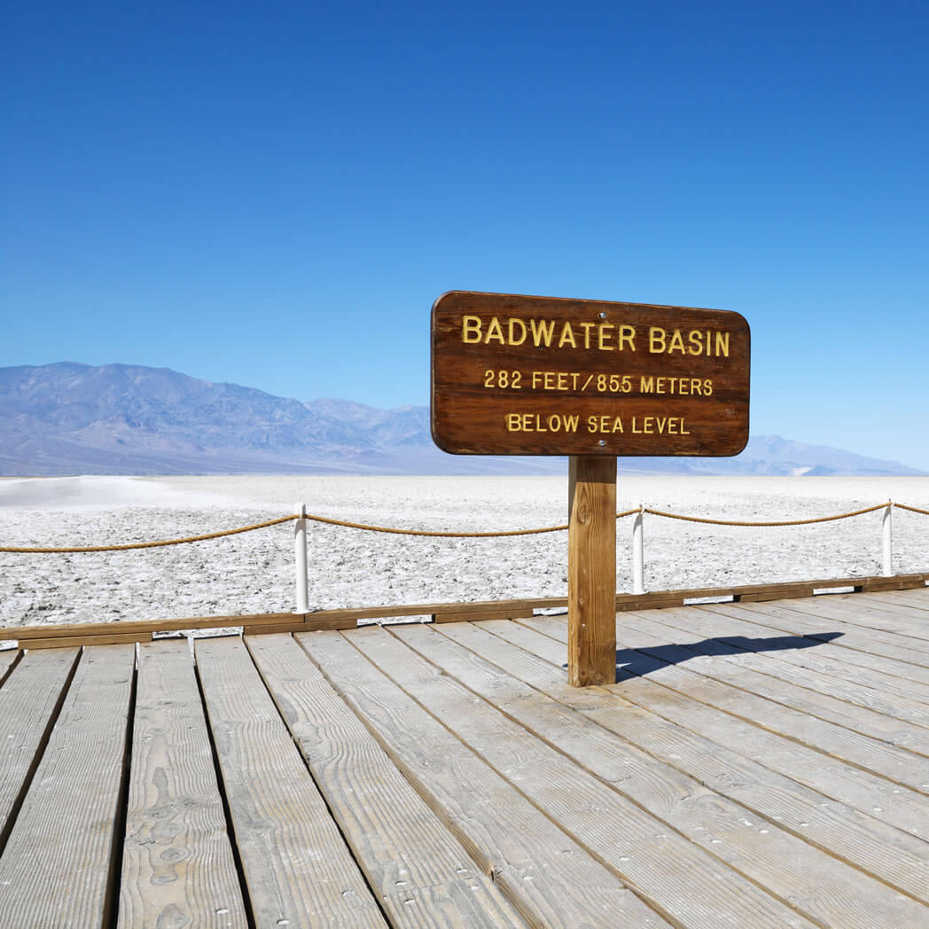
Badwater Basin is the lowest spot in North America, resting at 282 feet below sea level. Death Valley National Park photo
Dantes View – Located at an elevation of 5,758 feet directly above the Badwater Basin is Dante’s View. This extremely scenic view spot provides vistas of almost all of Death Valley. One can look straight down to the Badwater Basin and directly across to the Panamint Mountains and Telescope Peak. Far off to the west, are seen the Sierra Nevada Mountains, and to the east, numerous desert mountain ranges of Nevada. Located 25 miles east and south of Furnace Creek. The last few miles of roadway are steep and narrow.
Zabriskie Point – This viewpoint is accessed by a short drive and a steep short walk on a paved trail. The scene overlooks the beautifully eroded and colorful hills referred to as the badlands. Telescope Peak can be seen in the distance as well as the soaring peaks of the Funeral Range. Zabriskie Point is a favorite of photographers, providing perfect opportunities at sunrise and sunset. Located 2 ½ miles east Furnace Creek.
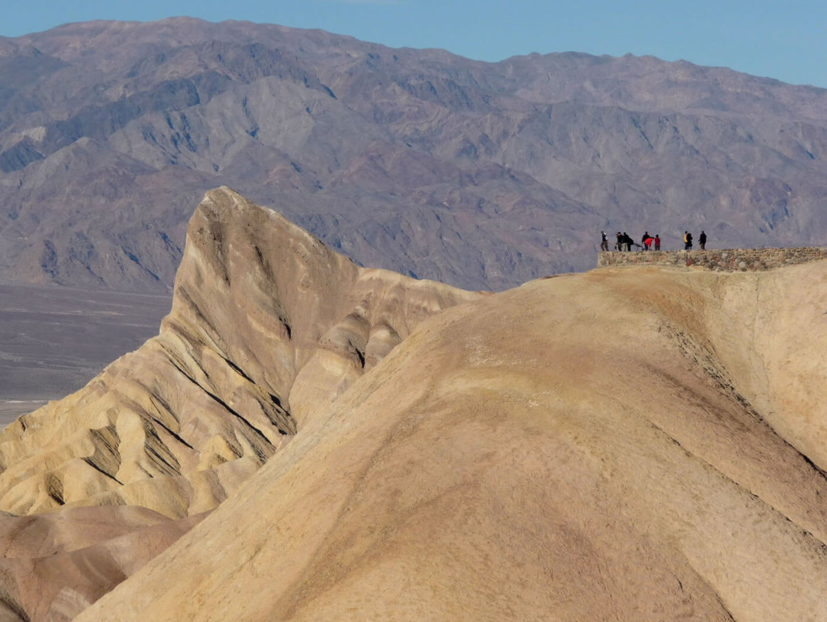
Zabriskie Point is both striking and accessible. Death Valley National Park photo
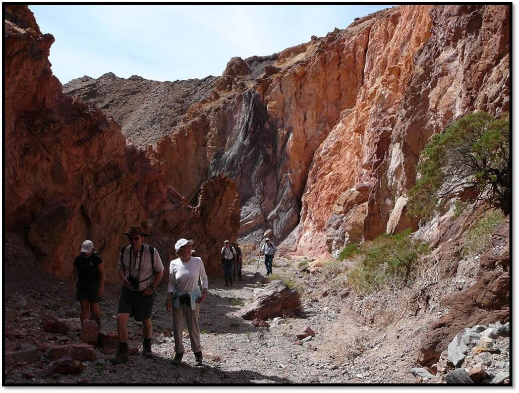
Golden Canyon – Penetrating deep into Death Valley’s Black Mountains is aptly named Golden Canyon. Especially in the morning light, the canyon walls glow magically with a flaxen hue. Golden Canyon is a hike, but one can get an intimate feel for it by walking just a few feet past its mouth. More adventurous trekkers can choose among a number of longer hikes. Located two miles south of Furnace Creek.
Golden Canyon lives up to its name. Shown is the hiking trail through the canyon and Manley Beacon. Death Valley National Park photo
Salt Creek – One of the few places on the actual floor of Death Valley where water flows, Salt Creek meanders along the surface on and off for several miles. This unique environment also provides habitat for Death Valley’s only native species of fish, the Desert Pupfish. Visitors can follow a wooden boardwalk along the banks of this desert treasure on a self-guided .half mile nature walk. Located 13 ½ miles north of Furnace Creek, then a one mile graded dirt road.
Mesquite Sand Dunes – Just a few miles west of Stovepipe Wells Village lay one of Death Valley’s most popular attractions, the Mesquite Sand Dunes. Covering over 14 square miles, the dunes provide some of the most dramatic scenery in the Park. Sunrise and sunset are both great time to catch just the right shot. Watch for the signed turnout about 23 miles north and west of Furnace Creek.
Ubehebe Crater – Most visitors are taken aback when they approach the yawning expanse of Ubehebe Crater for the first time. This “Maar” Volcano was created by a steam explosion as recent as only 300 years ago. 600’ deep and over a half mile across, visitors can take a steep path to the bottom (and back up), walk around its rim and simply stand at the edge of the parking area and take in the overwhelming scene. Located 57 miles north of Furnace Creek. The last five miles are on a narrow roadway.
Wildrose Charcoal Kilns – The Death Valley area has a rich mining history. Silver, gold, borax and talc are just come of the minerals that have been mined here. The ten Wildrose Charcoal Kilns are located at 7000 feet high up in the Panamint Mountains in a Pinion Pine Forest. These nearly perfect pieces of architecture were built in 1877 to produce charcoal for nearby silver smelters. About 62 miles from Furnace Creek, the last three miles on a graded dirt road.
Artist Drive – This scenic one-way, semi-loop paved road twists, winds, climbs and dips its way through some of the most colorful scenery in Death Valley. Highlight of the nine mile trip is the Artist Pallate, where hues of greens, purples, oranges, browns and yellows blend together in a kaleidoscope of color. Entrance to Artist Drive is located about 10 miles south of Furnace Creek.
The New Oasis with and Old West Feel at Death Valley
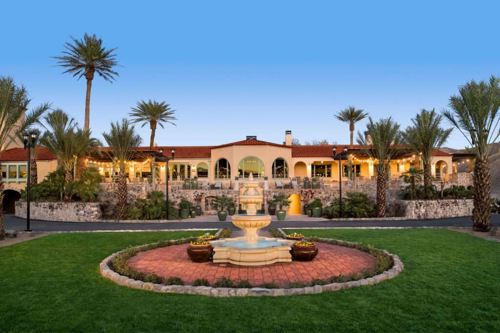
The new courtyard in front of the historic Furnace Creek Inn is one of many upgrades at the iconic Death Valley “oasis”. Photo courtesy of Xanterra
With a $100 million investment and a vision inspired by the Old West of novelist Larry McMurtry, Western art collector Phillip Anschutz and his Xanterra Travel Collection company recently transformed the resort properties formerly known as Furnace Creek Inn and Ranch in Death Valley National Park. Now known as the Inn and Ranch at the Oasis in Death Valley, both facilities were upgraded to reduce their carbon footprints, expanded, and in the case of the Ranch, almost completely redesigned.
The Inn at the Oasis has always been a luxury destination, said Trey Matheu, General Manager of the Oasis at Death Valley. Even when it first opened in 1927 without air conditioning, the Inn was designed for elegance and enticed Hollywood movie stars to vacation there. Perched at the edge of a low bluff, it overlooks a stunning view of the desert. Over the years, said Matheu, the Inn property has been upgraded and improved, but this most recent project was designed to take the already four diamond rated resort to the next level of luxury.
Twenty two private casitas were added to the property and now two full-time health and wellness specialists staff the new Tranquility Day Spa. The historic main building was given a face lift in which the designers took everything “down to the studs and built it back up to that 1927-era type of luxury,” said Matheu. Subtle changes made a big difference in the overall ambience, said Matheu, such as using natural wood and leather in the decor and adding many works of art from the Anshutz collection.
While amenities were added and the Inn expanded, it remained substantially true to its nearly 100-year-old original, classic design. A newly constructed wedding and events venue across from the Inn rose Phoenix-like from the ashes of a past structure. Now an old Mission style garden provides a stunning backdrop built upon the remains of a few historic adobe walls.
“The Oasis used to be a place you’d stay to explore Death Valley. Now it’s becoming a destination resort that happens to have a national park as one of its amenities,” said Matheu.
THE COURTYARD AT THE RANCH AT THE OASIS.
Meanwhile, back at the Ranch
The Ranch at the Oasis underwent the most dramatic transformation during the remodeling process, especially in the entry area now known as the courtyard. This is the social center and the “heartbeat of the property,” said Matheu. In 2017 the old café, gift shop and buffet building was razed and rebuilt from the ground up in a style that evokes the kinds of Western places author McMurtry writes about.
Xanterra’s Anshutz owns possibly the largest collection of Western art in the world, said Matheu, and is a fan of Western literature. After reading McMurtry’s Last Kind Words Saloon, released in 2014, Anshutz purchased rights to the name, hoping to use it for one of his properties. Death Valley seemed the perfect fit.
The architecture, explained Matheu, is Spanish Colonial-inspired, built to resemble an old-fashioned plaza. The new building includes an ice cream shop, a buffet, a two-story sit down restaurant and saloon, complete with swinging doors, called the Last Kind Words Saloon, and an expanded gift shop (where you can buy McMurtry’s eponymous novel, among other things). The walkways have misters for the hot summer weather and the grounds offer plenty of outdoor park style seating, as well as a children’s playground and basketball and volleyball courts.
The saloon is lavishly decorated with original works of American Western art and artifacts evoking a general southwest/Old West feel. While the theme is now more general Western nostalgia, “it’s always been our goal to keep the connection with the roots of Death Valley,” said Matheu. To that end, Xanterra kept the old Borax Museum open in its original location.
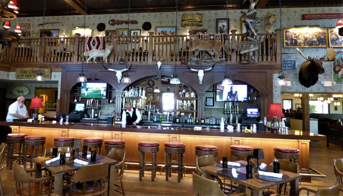
The western themed Last Kind Word Saloon at the Ranch at the Oasis.
All of the renovations were done with an eye toward reducing Xanterra’s footprint in Death Valley, said Matheu. Updating or rebuilding the structures at the Ranch significantly reduced water usage and improved efficiency in electrical consumption. This allowed Xanterra to provide more landscaping while still using less water than before.
The world famous Furnace Creek golf course, adjacent to the Ranch, remains essentially the same, said Matheu, however some of the course was converted back to desert landscape. “It looks a little different but the green is the same experience,” said Matheu. The popular 19th Hole restaurant was able to double its seating and add some covered patio space with an unobstructed view of the desert.
The Ranch’s 224 guest rooms were given fresh paint and new carpeting and Matheu said Xanterra plans to add more guest cabins to the property by 2020.
Along with the new look come new options for entertainment at the Oasis, said Matheu. Xanterra is excited to offer weekly night sky viewing presentations on the golf course. They will continue to offer old favorites such as horseback and carriage rides from the Furnace Creek stables, “dive in” movies at the Ranch swimming pool, and simple pleasures such as corn hole and horseshoes.
And of course, access to hiking and exploring the extraordinary desert.
Matheu highly recommends visitors make reservations for a stay at the Oasis. Visitation has increased since the facilities reopened in 2018, with growing numbers of international tourists coming to catch a glimpse of the historic American West.
For more information, visit OasisatDeathValley.com
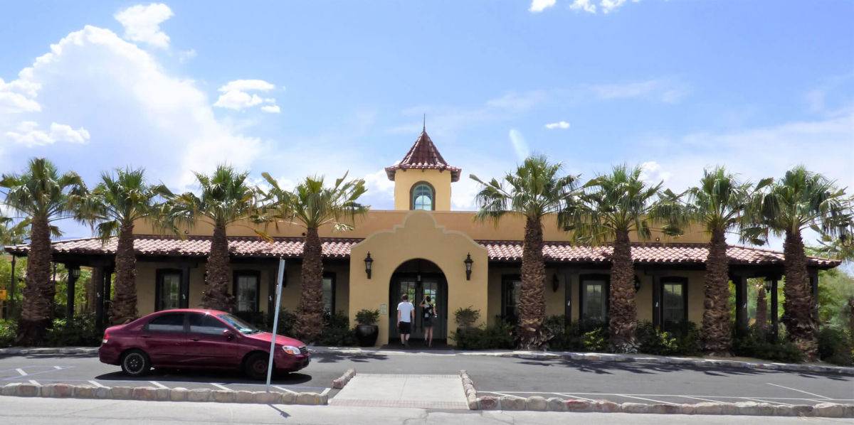
The entrance to the Ranch at the Oasis is one of several new buildings at the historic location.
Unique Dining Options in Tiny Tecopa
The tiny town of Tecopa, on the southeastern edge of Death Valley National Park, may possibly be home to more restaurants per capita than any city in the US. With four restaurants and an official population of 150, Tecopa beats by more than half the average of larger cities that make this claim. Front runner Durango, Colorado, calculated its average in 2018 as one restaurant per every 88 residents. In Tecopa, it’s one per every 37. Two of those four establishments also include onsite brew pubs, likely to be the highest number of pubs per capita compared to any city in the country at one per every 75 inhabitants.
Of course, the Tecopa restaurateurs depend on more than local residents to keep their kitchens busy and they employ a variety of creative strategies to attract visitors to their tables. Using as many locally grown ingredients as possible, relying on family recipes and the genius of visiting chefs, playing live music or brewing “weird beer” these eateries offer an eclectic array of choices.

A Las Vegas chef runs Steaks and Beer with attention to detail and quality. Photo by Robin Flinchum.
Steaks and Beer, located in the “downtown” area of Tecopa, is a popular hole in the wall with a tiny dining room and spacious patio seating area built over a fish pond. Owner and chef Eric Scott learned his craft on the Las Vegas Strip and has a gift for preparing steak, as well as a humble charm that makes eating at his restaurant like stopping by the house of a friend. He’s been cooking here for over three years, most of the time as a one-man operation, though he sometimes hires an assistant when things are especially busy.
Scott’s menu includes steak, of course, and options such as a five course meal for two, gluten free vegetarian pasta and a miso bone broth with seafood and udon noodles. For the beer end of things, Scott relies on the Death Valley Brewing Company next door.
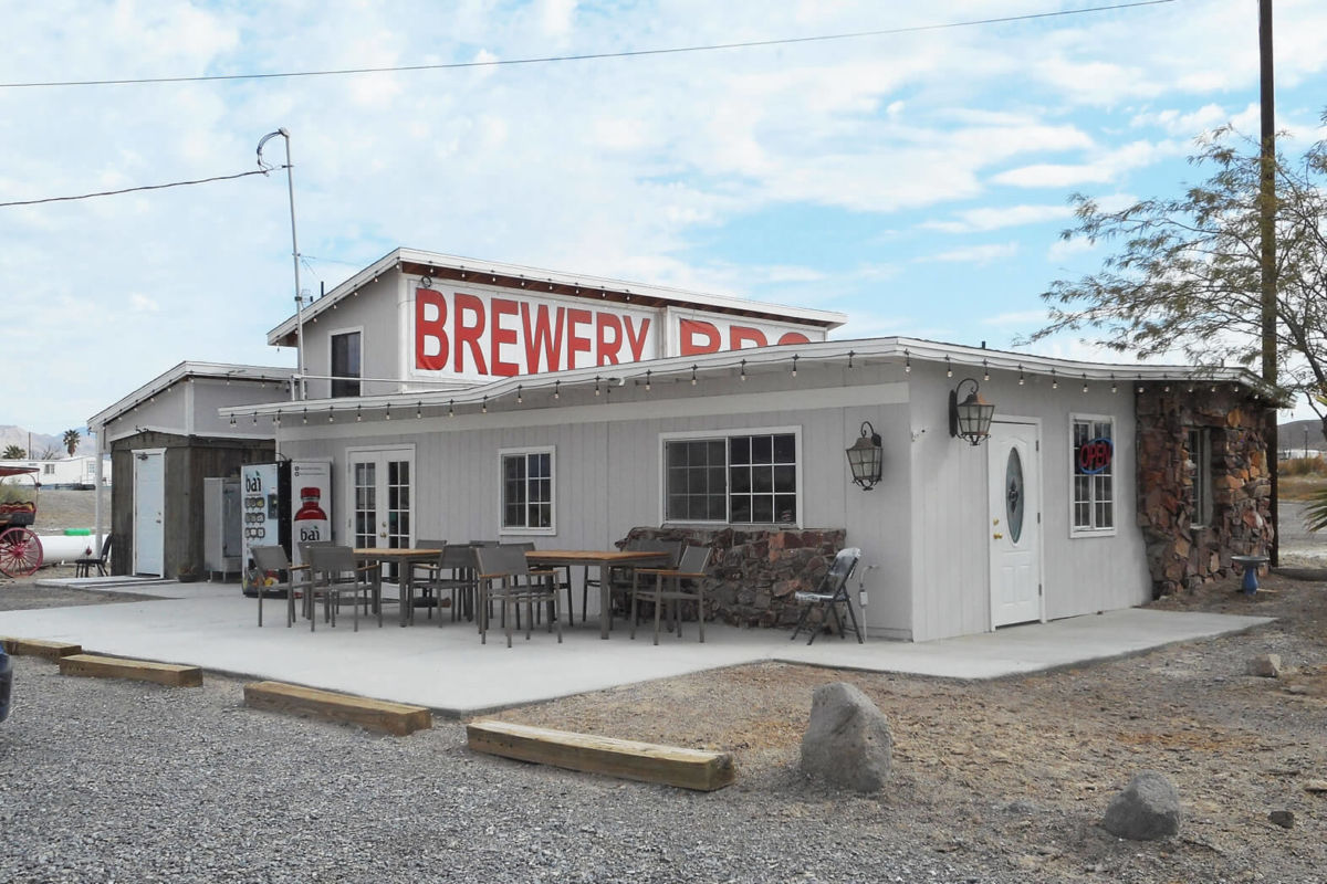
The recently expanded space at Death Valley Brewing. Photo by Robin Flinchum.
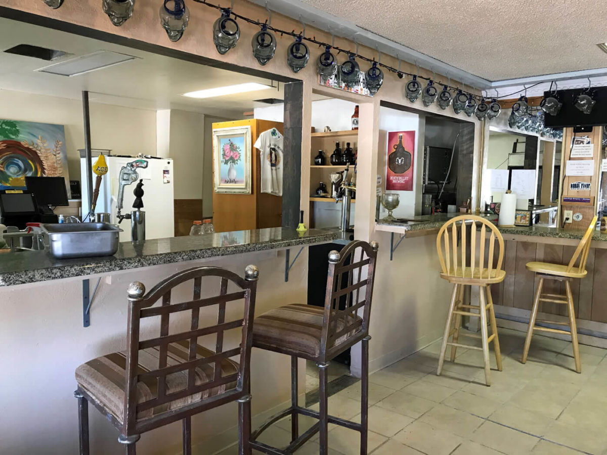
Death Valley Brewing is entering its sixth year as a brew pub with an ever changing and always inventive beer menu. Owner Jon Zellhoefer and manager Dan Leesburg are both passionate about the craft of brewing and, while they will keep a few regular favorites on tap, they are always excited to try the next new recipe. The pub recently expanded its kitchen and serves pizza with a variety of topping options for its patrons, as well as soft pretzels.
Death Valley Brewing also offers unusual premiums to their loyal customers, such as the crystal skull mugs sold the first year the pub was in business. This year, they are offering steins as a premium for membership in the brew club, which includes discounts on beer purchases, t-shirts and more. The pub also has a large recreation room with a billiards table, an unusual desert disc golf course out back, and they recently began selling California lottery tickets for visitors who are feeling lucky.
The Tecopa Brewing Company is a family operation featuring BBQ and locally crafted beer. Photo by Robin Flinchum
On the other end of town is the Tecopa Brewing Company and BBQ restaurant, on the grounds of Delight’s Hot Springs Resort. Going into its fourth season, the restaurant caters to the resort’s overnight guests, as well as travelers passing through. It’s open seven days a week and offers breakfast (weekends only) and lunch as well as the traditional BBQ dinners. This year, the restaurant hired a new chef trained in classical French cuisine, said owner Courtney McNeal, and they’ll be offering weekend specials paired with one of their craft beers. With the new chef of board, brewer Wes McNeal will have time to focus on crafting new lager and ale recipes for the pub.
The Tecopa Brewing Company also often hosts live music and other events on weekends.
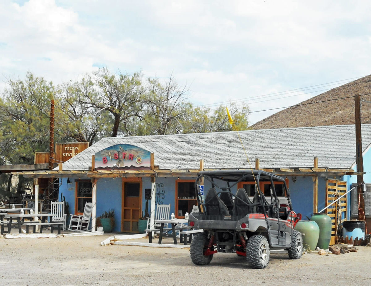
The Tecopa Bistro is the longest running eatery in town. PHOTO BY ROBIN FLINCHUM
In between the two pubs, in the heart of Tecopa Hot Springs, is the Tecopa Bistro, the longest running of all the local eateries, opening its doors on the grounds of the Tecopa Hot Springs Resort over ten years ago. The Bistro changed ownership since then and underwent renovations to upgrade its kitchen to industry standards. This cozy, quirky eatery offers American fusion fare and is focusing on Food as Art in the 2019-2020 season, said owner Ryan Thomas. “It’s the equivalent of an art gallery for people who cook.” The Bistro invites guest chefs who have a specialty dish to share. On the regular menu Thomas uses herbs, veggies and even meat grown on his own small farm in Tecopa.
Thomas and his business partner Paul Barnes are both musicians and play live with their house band every weekend on an outdoor stage next door to the restaurant. With lots of patio seating, the Bistro patrons can enjoy the music and the fresh desert air.
Quirky, Comfy Lodging Brings the Outdoors In and Vice Versa
Reinvention, renovation and an emphasis on the natural world around them are continuing themes for the entrepreneurs running hospitality businesses on the south-eastern edge of Death Valley National Park. In Tecopa, Shoshone and Death Valley Junction hotel proprietors are focusing on their unique geography, history and eco-biology to offer visitors an unusual desert experience.
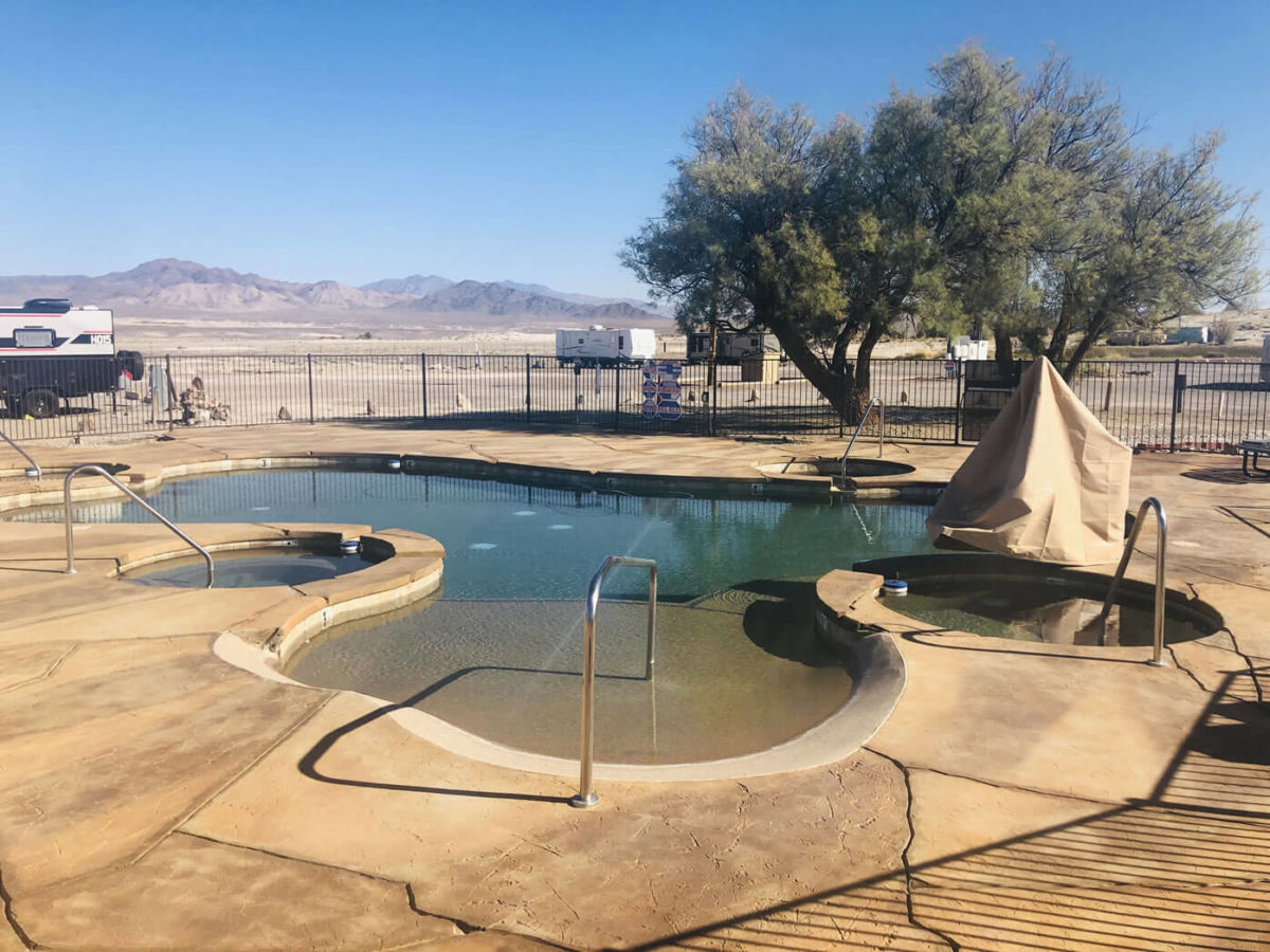
The newest soaking pool at Delight’s Hot Springs Resort. PHOTO BY ROBIN FLINCHUM
Delight’s Hot Springs Resort is one of the oldest continually running businesses in the small town of Tecopa with four individual, private hot mineral water pools that have been the heart of its existence for decades. The pools are sheltered within a courtyard, protected from the wind and sun. Now, for visitors who want to experience the hot springs waters out in the fresh desert air, owners Wes and Courtney McNeal designed and built a large outdoor soaking pool.
The elegant new feature is made up of several smaller, hotter pools flowing into a central pool maintained at or a little below 100 degrees and has a lovely, unobstructed desert view. While the private pools at Delight’s are clothing optional, the outdoor pool is suits required.
Delight’s offers six historic adobe cabins and three studio rooms. The property includes an RV park and an onsite BBQ restaurant and brew pub.
Tecopa has four hot springs resorts offering a variety of rejuvenating experiences. Photo by Bill Neil
The Tecopa Hot Springs Resort found its niche bringing music outside. It’s home to an outdoor stage where a live house band plays every weekend through the cool weather season and other bands perform at special events. The Tecopa Take Over, held every year in November, is a growing desert music festival held on the grounds.
The Resort offers 16 motel rooms, 4 cabins with kitchenettes, tent camping and RV spaces. Also on site is the Tecopa Bistro, an American fusion restaurant featuring farm to table ingredients grown in Tecopa, and an art gallery in the Resort office.
Across the street from the Resort, the Tecopa Hot Springs Campground offers tent camping, RV spaces and two camping cabins with comfortable beds and air conditioning. It also hosts a couple of colorful vintage trailers bookable through Air B-and-B.
Also in the heart of Tecopa, the Tecopa Palms RV Resort is open for RV parking and social activities in the club house this season, while pools are temporarily closed. Call for more information.
Visitors to Villa Anita get a unique, immersive desert art experience. Photo courtesy Villa Anita.
Out on the edge of Tecopa, Villa Anita is an immersive art and lodging experience. It is a combination B-and-B, performance piece, and living work of art. The proprietors, artist David Aaron Smith and photographer Carlo Roncancio, and their partners live and work at the Villa along with guests, volunteers, interns and other artists.
The sometimes gothic, sometimes earthy, sometimes startling and always creatively original architecture and décor draw artists, film makers, adventure seekers and even wedding planners from all over the world. The structure is an ever expanding maze of art piece rooms constructed of many found objects, including vintage trailers.
Cynthia’s Safaris helps visitors explore the desert. Photo courtesy Cynthia’s Safaris.
Cynthia’s Safaris in Tecopa is shifting focus, said owner Cynthia Keinitz, from individual lodging to group events, especially intensive retreats. Former interior designer Keinitz’s unusual B-and-B is simple on the outside, blending into the landscape she loves. Inside it is designed to always emphasize the outside world, to provide easy comfort and incredible views, a draw to explore the desert and a good night’s sleep in elegant comfort at the end of a day well spent.
Cynthia’s offers off-road tours and an eclectic variety of experiences for group visits. The lodging facilities include remodeled trailers and tipis and a stay usually includes meals prepared with local farm to table ingredients.
The recently remodeled Shoshone Inn offers a touch of comfort in the desert. Photo by Robin Flinchum
In Shoshone, town proprietor and desert advocate Susan Sorrells is adding to the lodging opportunities available with a few stand alone properties. In addition to the Shoshone Inn, which offers 17 upscale rooms, guests can now book though Air B-and-B for a remodeled vintage trailer called Dutch’s Retreat, a historic cabin called Black Rock, or the Mojave Bunkhouse, designed for group stays. The Shoshone RV Park also offers tent camping and all guests in Shoshone have access to the town’s delightful warm springs swimming pool. Meals can be had all day and evening at the Crowbar Café and saloon, offering traditional diner and Tex-Mex fare.
Shoshone keeps a naturalist on staff to help visitors to this eco-village find their passion. Options include environmentally responsible off-road tours, wildlife viewing at the Pupfish Pond natural area, dark night skies, bird watching and plenty of hiking.
New in Shoshone this season is Karin Pine’s Transformational Bodywork Clinic. In her well established former practice, Tecopa Hot Springs Massage, Pine developed “a very effective and unique form of healing massage as part of the healing experience of visiting the desert.”
Out in Death Valley Junction the Amargosa Hotel is continually upgrading in small ways. The nonprofit Amargosa Opera House foundation that runs the facility is careful not to disturb the historic character of the hotel while working to make its 16 rooms as comfortable as possible for modern day visitors. Guests experience the real history of the place, says manager Bobbi Fabian, enhanced by understated details, such as new beds, fluffy pillows, fresh paint and friendly service. To encourage immersion in the desert silence and enjoyment of the truly dark night skies, there are no TVs in the rooms. An on-site restaurant serves California cuisine style breakfast and lunch in a historic setting with windows onto the desert.
Marta Becket’s Amargosa Opera House lost its famed founder in 2017 but continues to offer a wide variety or quirky, clever, and unusual entertainment to its fans and visitors. From original interactive murder mystery plays to unusual opera, ragtime and the Nutcracker ballet at Christmas, the venue seeks to honor Becket’s legacy of promoting the arts.
Tecopa is also rich in hiking opportunities, most notably the Grimshaw Lake Natural Area and watchable wildlife site, and the Amargosa Canyon. Accessing the extraordinary desert vistas of the Amargosa Canyon is easy now that an official trail head, with picnic ramadas and a pit toilet, exists at the edge of the parking lot of the China Ranch Date Farm. Stop here to see a working farm in a desert oasis, stock up on local dates and a trail guide at the gift shop.
After a roundabout trip, the Borax Wagons are Home at Laws
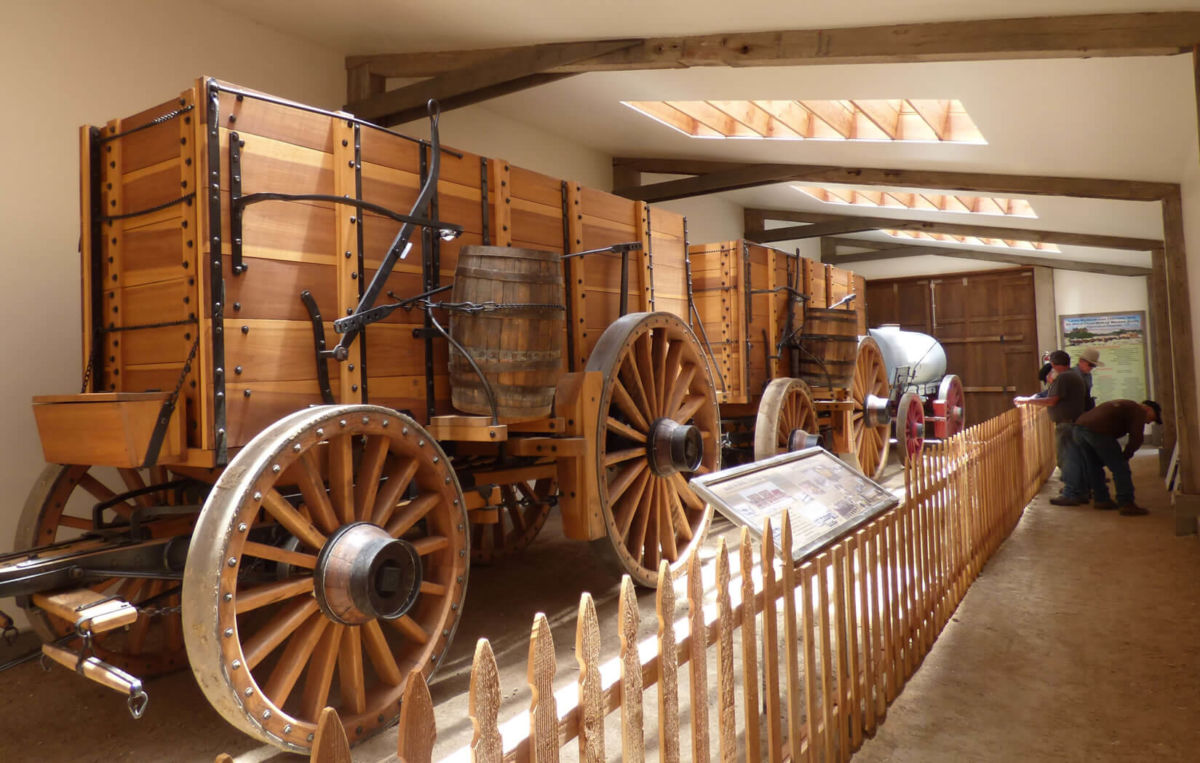
The two huge Borax 20-Mule Team Wagons and trailing water tank at the new barn at Laws Railroad Museum.
The instantly recognizable Borax 20-Mule Team Wagons took a bit of a roundabout route to their new home in an impressive, brand new barn at the Laws Railroad Museum and Historic Village.
The first leg of that journey involved nearly a decade of research and work and fundraising that eventually resulted in the construction of the huge, historically accurate wagons and the gear needed to hitch 20 mules to the two big freight wagons and the water tank rolling behind them.
Once the wagons were ready to roll in 2016, they were re-introduced to the public by rolling down some pretty impressive boulevards. First came the Pasadena Rose Parade, a California New Year’s Day tradition known around the world. Then the wagons and mules ventured through Washington, D.C. to help celebrate Independence Day on the National Mall in the nation’s capital.
While those parades have their fans and carry a tad of prestige in the world’s eyes, in the Eastern Sierra the crowning achievement of the 20-Mule Team Borax Wagons came when the whole outfit starred as one of the crowd favorites during several trips down Bishop’s Main Street during the annual Mule Days Parade.
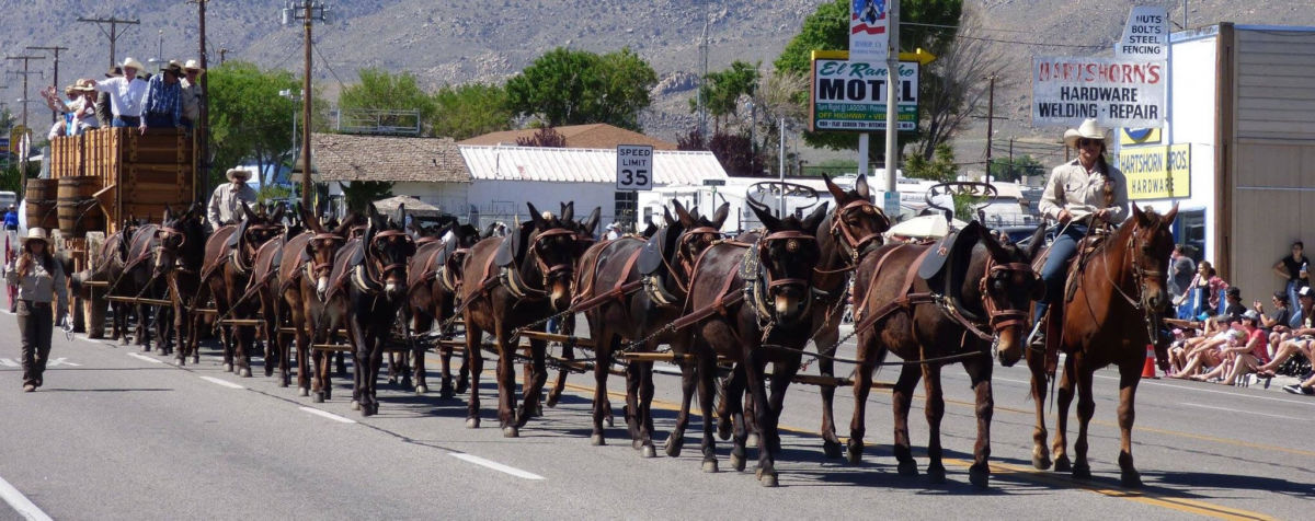
Bobby Tanner and his crew bring Borax 20-Mule Team Wagons down the Mule Days Parade Route in 2017.
The local pride came from two sources. First was the familiar face of longtime Eastern Sierra packer and teamster Bobby Tanner who helped bring the wagons back to life and personally maneuvers the huge wagons pulled by 20 mules, working two abreast, down the parade route. Second, the 20-Mule Team and Borax are both local products and local legends that contributed mightily to the notoriety and ongoing mystique of the Death Valley region, Inyo County’s premiere tourist attraction.
Finally, after dazzling yet another Mule Days crowd this year, the wagons headed for their new permanent home. On Memorial Day, May 28, a crowd of about 100 came to Laws to help dedicate the new, Borax 20-Mule Team Wagon Barn.
The big wagons were in the barn and, even without a cadre of mules, dazzled the crowd. The big, back wheels are 7-feet high. The wagon box towers above the big wheels. The wagons are made of a beautiful, lightly stained wood. In contrast, dozens of black bolts dot the wagon boxes in a testament to the authentic wagon-building trades that created the rolling historical replicas. The barn itself is first-class. The skylights in the roof send splashes of sunshine on the wagons. Long, white walls await additional photos and explanatory text. Those final touches will be added as time goes on, thanks to a collaboration between Laws and the Bishop-based American Mule Museum.
Besides those two local groups, the non-profit Death Valley Conservancy and Rio Tinto Borates (formerly Pacific Coast Borax), also played critical roles in bringing the 20-Mule Team back home to Inyo County.
Tanner addressed the crowd and recalled how, about 10 years ago, he contacted Howard Holland, the talented exhibit designer and board member of Laws Museum, with what Tanner called “a scheme” to build replica borax wagons. And now, after years of work and even more “scheming,” the wagons and their new home at Laws are a reality.
While touring the country with the wagons, Tanner said the real “eye opener” was that so many people, whether in Kansas, Ohio or Maryland, recognized the 20 mule team and wagons. Especially those from farm families or those who were familiar with mules, “knew exactly what they were looking at” when they approached the huge wagons. Part of the reason for the wagons’ notoriety, he added, came from “Ron Reagan” who hosted the TV show “Death Valley Days,” sponsored by Borax and featuring the wagons. Of course, “Ron” is also known as the former governor of California, president of the United States and, most importantly, one-time Grand Marshall of the Mule Days Parade.
While the 20-mule team can seem like “a local thing,” Tanner assured the crowd that “this is a significant deal,” and the Borax wagons and the 20-mule team is still “an American icon.”
Tanner then recalled how one man had an out-sized impact on the wagon project. In 1999, Rose Parade officials contacted Borax and asked if the company could bring the famed wagons and mules to the parade. The company had marketed “20-Mule Team Borax” from 1906 to1950. But most company officers did not want to revive the wagons.
But one corporate officer turned that thinking around and started the process to bring the wagons back, Tanner said as a way to introduce Preston Chiaro. He was managing the Boron mine at the time, and knew the Eastern Sierra. More important, he knew the Tanner family as the packers at Red’s Meadow.
He got the wagon idea turned around in the corporate offices. Then he was able to see the project through to completion since he eventually became president of US Borax, which was owned by Rio Tinto at the time – the most recent name for the Borax Company, which was known as Pacific Coast Borax when it built the first borax wagons to haul the mineral out of its Death Valley mines.
“These wagons have a real power,” Chiaro told the crowd. “It’s the power of an idea, and that idea is the development of the West.”
Chiaro noted that Rio Tinto put up a $150,000 challenge grant that made the fabrication of the wagons possible, along with the outpouring of support and donations from individuals and organizations. Another, even tougher obstacle was who could manage the mules and wagons. “Driving a 20-mule team was a lost art,” he said. Enter Bobby Tanner and his crew. Then came years of painstaking research followed by exacting construction and fabrication using 19th and early 20th century wagon-building skills and “technology.”
Once completed and rolling, Chiaro noted that a special aspect of the sight of the wagons in action is that “there is a beauty about it,” as 20 mules work in unison and respond to the commands of the teamsters. After watching the mules and wagons perform in parades large and small, Chiaro said it is easy to see the “magic” created by the imposing, vintage vehicles. “It sparks peoples’ imagination.”
And now, people can visit the wagons in their new, home barn at Laws, and let their imagination run wild.
One of the two, huge Borax 20-Mule Team Wagons in the new exhibit barn at the Laws Railroad Museum.
How ‘White Gold’ led to naming Twenty Mule Team Canyon
Instead of yet another Devil-related name, the scenic canyon behind the Furnace Creek Inn was named 20 Mule Team Canyon to link it with the Borax Company’s famous, widely recognized soap products, even though Borax was not mined in the canyon, and the 20 Mule Teams never visited. Death Valley National Park photo.
In the fall of 1926, the Pacific Coast Borax Company (Borax Company) was nearing completion of its first hotel in Death Valley, the Furnace Creek Inn. At this time, Death Valley enjoyed no protective status as a National Monument or National Park. In fact, the very few roads that existed in the Death Valley region had all been built as part of the Borax Company’s mining operations.
Long-time Borax Company employee and Land Superintendant Harry Gower had been assigned the task of overseeing construction of the new hotel. The details involved in its construction along with the horrific construction schedule demanded by the Borax Company executives had consumed Harry and his staff. As the construction work was winding down and the opening of the hotel was just a few weeks away, it occurred to Harry that the arriving tourists would want to enjoy some scenic views and have some historic points to visit while staying at “the Inn.”
Thus, the race was on it not only to develop a few of these points of interest, but to name them as well.
The name Death Valley already conjured up an image among the American public of fear, morbidity and a land inhabited by reddish ghouls with pointed ears, tails and pitchforks. Harry and the Borax Company thought it a wise marketing strategy to continue with this association. Devils Golf Course, Funeral Mountains, Badwater and many more Dante/Inferno-type names soon appeared on maps as “must see” places for the Death Valley visitor.
But Harry Gower also understood the huge marketing potential if they could promote the use of its magic soap product Twenty Mule Team Borax through the appeal and romanticism of soon to be opened Death Valley. Names that would help the traveling public to easily associate with their “white gold” (which was readily available at the local grocers back home) were also chosen for some of the tourist sites.
Four miles east of the Furnace Cree Inn lay a twisting and colorful canyon just south of the main thoroughfare through Furnace Creek Wash. Harry (or perhaps someone on his staff) suggested naming this beautiful spot Twenty Mule Team Canyon. They didn’t seem to mind that the famed Twenty Mule Teams never traveled through here. The canyon was so narrow and twisting in places, that a team of two horses would have difficulty navigating through parts of it. But all of the arriving tourists to the soon to open Inn would have to travel right past this spot, and see its sign. A more innocuous form of using nature to help market a product may have never been devised!
The short 2.5 mile drive through Twenty Mule Team Canyon provides visitors with beautiful and scenic vistas along with many hiking opportunities. Twisted, eroded and eerie formations abound. There are significant borax deposits found in the hills and mountains here and though the Borax Company never actively mined this location, it did carry out extensive development work to establish the value of their deposits. Hikers can explore the area but for their safety, should never enter any old mine.
Dante’s View: The “jaw-dropping” vista Dante’s View
Dante’s View overlooks Badwater Basin, the lowest elevation spot in North America. National Park Service photo.
In the fall of 1926, the Borax Company was nearing completion of its new hotel, the Furnace Creek Inn in Death Valley. Knowing they would need scenic points of interests for their guests to visit when they arrived, hotel executives asked residents in nearby towns if they knew of a particular “jaw-dropping” viewpoint.
More specifically, the mining executives were looking for an accessible view point that would provide not only sweeping vistas of the Valley, but of far off Mt. Whitney as well. This would give tourists the thrill of seeing both the lowest and highest points in the contiguous United States from the same spot.
Businessmen in the gateway town of Beatty, Nevada tried to promote a nearby area known as Chloride Cliffs which they fittingly renamed “the Rim of Hell.” They convinced Nevada governor James Srugham to fund the widening and improving of a road to the point through Nevada, and on into California as well! When the Borax Company and their railroad partners came out to take a look, they agreed that this might just be the view spot they were looking for.
But as the group was returning to Los Angles, they stopped in the small town of Shoshone and asked long time local Charles Brown if he knew of a better spot. “I don’t pay much attention to scenery,” said Charles. “But I know one view that made me stop and look.” When he took the party to it, they immediately agreed. Far below lie the shimmering salt flats of Badwater, at 282 feet below sea level, while in the far off distance glimmered the Sierra Crest just north of Mt Whitney. A road was quickly graded and a small six-sided glassed in observatory was erected at the top.
The name of the viewpoint was said to have been inspired by Dante’s description of Purgatory.
Today, a well-designed paved roads winds its way to the parking area at Dante’s View. Located about a 30 minute drive from Furnace Creek, the views from the top are truly stunning and breathtaking. Not only can one see the two aforementioned spots, but a multitude of others as well. Telescope Peak, rising two miles about the great Valley’s floor looms grandly to the west. The views up and down the Valley offer vistas so vast and “other worldly” that they were used as a backdrop in the original Star Wars movie. To the East is majestic Mt. Charleston, home to the Las Vegas area’s only ski resort. Straight down, cars crawl their way along the Park’s road like ants.
The view from Dante’s view is spectacular no matter what time of day you make it there. But should time allow, arriving in the early morning and watching the desert sky pass from inky black through indigo, deep purple, violet, red, orange, yellow and on to bright white, is an experience one will never forget. And watching the sun go down and the lights go out on the great Valley at sunset is an experience that will rival that of sunrise.
There are short hikes that lead north and south of the parking area. There is no longer an observatory but primitive restrooms are located at a switchback about 1/4 mile before the top. Take a jacket, pack a snack or a meal, and spend some time at this magical Death Valley spot. You’ll find the time you spend here very well worth it.
Stars put on a spectacular show every night in Death Valley
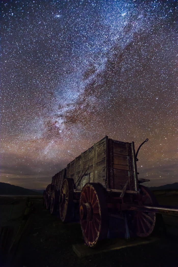
The bright night sky and the Milky Way shines above the Harmony Borax Works. Photo by Weston Kessler
Death Valley National Park harbors some of the darkest night skies in the United States. That dark sky is key to its certification as the third International Dark Sky Park in the U.S. National Park System.
“Death Valley is a place to gaze in awe at the expanse of the Milky Way, follow a lunar eclipse, track a meteor shower, or simply reflect on your place in the universe,” said National Park Service Director Jonathan B. Jarvis when the certification was announced in 2013. “We greatly appreciate the International Dark-Sky Association certification. It illustrates the park’s commitment to protect natural darkness and supports the wider mission to protect nightscapes in the entire National Park System.”
“As the world becomes more urbanized,” Jarvis added, “the value of a starry sky only increases and our ability to offer visitors these incredible experiences is an integral part of the National Park Service mission to preserve our nation’s most cherished places for this and future generations.”
Death Valley’s natural darkness, along with National Park Service actions to reduce excessive outdoor lighting, led the International Dark-Sky Association to designate the park as the third and largest International Dark Sky Park.
“The Dark Sky Park designation represents not only the efforts of the park and its partners, but the dedication of avid amateur astronomers who have sought the park’s world-class starry skies for decades,” said Dan Duriscoe, of the National Park Service’s Natural Sounds and Night Skies Division.
To qualify for the dark sky designation, the park improved external lighting at facilities in the Furnace Creek and Stovepipe Wells areas, reducing energy consumption, sky glow, and glare. The designation requires the park to sustain its efforts to protect night sky resources and visitor education. Implementation of the park’s lighting guidelines will improve the natural character of the night and leave the stars untarnished in other areas of the park.
“At Death Valley the sky literally begins at your feet,” said Tyler Nordgren, Associate Professor of Physics at the University of Redlands (Calif.) and International Dark-Sky Association board member. “When my students and I look up at night from our southern California campus, we can usually count 12 stars in the sky. However, less than a five hour drive from Los Angeles there’s a place where anyone can look up and see the universe the way everyone could 100 years ago.”
Tips for viewing and photographing the night sky in Death Valley:
- Visit during the new moon — this is when the moon is not visible which means the sky will be darker and you can see more stars.
- Know what to look for — check out the night sky almanac to right to get an idea of what might be visible and where.
- Stay out long enough — it takes about 30 minutes for your eyes to adjust to the night sky to see the most stars.
- Use a red light —or put a piece of red cellophane on your flashlight. This will minimize the effect of the light on your adjusting eyes.
- Look at the horizon — Death Valley has large, towering mountains. If you pick a low place to view the night sky, like Badwater Basin, some of the stars could be blocked by the mountain ranges. Pick a large open area with some elevation to see the most stars.
- Bring binoculars — a simple pair of binoculars can be a great way to get a closer look!
Where to go
- Harmony Borax Works is located close to the Furnace Creek Visitor Center and provides a great place to see the stars with little obstruction from the mountains. There are also historic buildings and a mule cart for night photography, which will make for an interesting foreground.
- Mesquite Flat Sand Dunes is located close to Stovepipe Wells and is a great spot for seeing A LOT of sky. Unobstructed views can be found here, but the close proximity to the highway means the potential for light pollution from headlights.
- Badwater Basin is located 17 miles south on Badwater Road. Milky Way viewing can be somewhat obstructed from the mountains, but seeing the night sky from the salt flats is a unique, other-worldly experience! Not to mention that the salt flats are great for the foreground of a night shot.
The Racetrack Playa and the ‘magic’ moving rocks
Famed naturalist John Muir once said, “Everybody needs beauty as well as bread, places to play in and pray in, where nature may heal and give strength to body and soul.” Nature has many such temples. A place where one may visit and feel the power of the natural scene fill them with strength and renewed enthusiasm for life. Where the magic of the setting brings forth the very best in us all.
Death Valley National Park is a land of extremes, oddities and mystery. Tucked away in a remote corner of this expansive wilderness, lies a very special place. A place of great beauty, of great mystery and of much magic.
The Racetrack Playa lies at an elevation of 3,608 feet. The Playa is a dry lake bed, about 3 miles long and 1 1/2 miles wide. The surreal setting is stunning. The exceptionally flat play glistens creamy white is the desert sun, and is surrounded by dark, brooding and barren mountains. About 1/3 of the way down the playa, a small island of dark rocks thrusts dozens of feet into the desert sky.
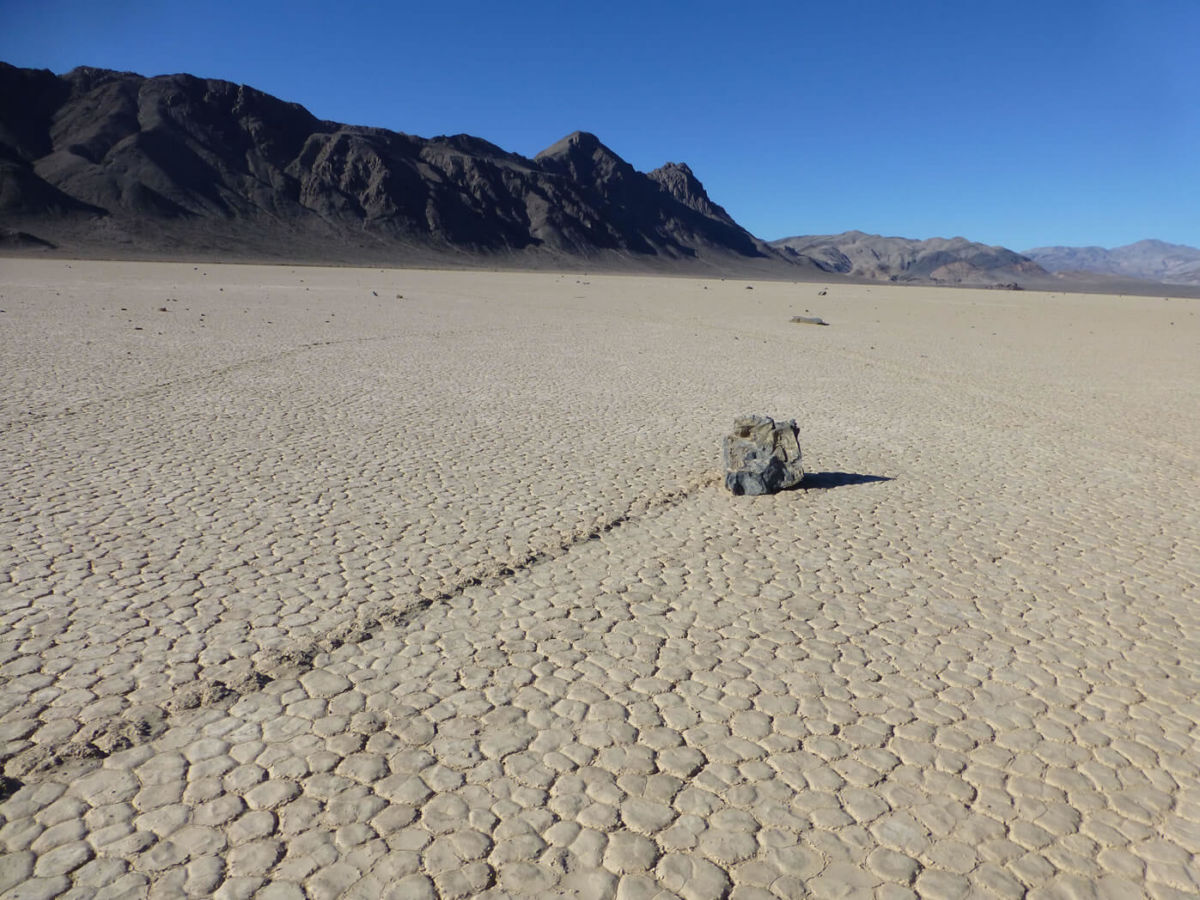
The famed “moving rocks” dot the Racetrack Playa.
Walking on the Playa is an experience in itself. The vastness of this landscape becomes intensified the further you walk on to this old dry lake bed. As you travel toward the southwest corner, you begin to notice the Playa has become littered with dozens of rocks. And the unusual thing about these rocks is that many of them have a distinct trail furrowed into the playa surface trailing from the rock as if to indicate the direction the rocks have come from. Some of these trails are straight, most are zig-zagged, many are curved and even some make 360-degree loops.
These are the famous Moving Rocks of the Racetrack Playa. The Rocks have been studied by scientists for decades. No one knows for sure exactly how these rocks “move” though there is a most widely accepted (but not the only) theory.
During winter rains, enough water may fall to form a shallow lake over the playa. As the water begins to evaporate, a thin layer of soft slick mud will form on the playa surface. At this high of an elevation, freezing nights and even days are not uncommon during the winter months, freezing the slippery slick mud. Like many desert basins, the winds blow often…and often they blow with exceptional velocity. Strong winds will literally push the rocks across the partially frozen and slippery mud playa. As the winds change directions, so does the course of the rocks.
The power of the scene will bring the most jaded urban dweller to their knees in this holiest of nature’s temple. The stark and vast beauty combines perfectly with natures “magic” of the moving rocks.
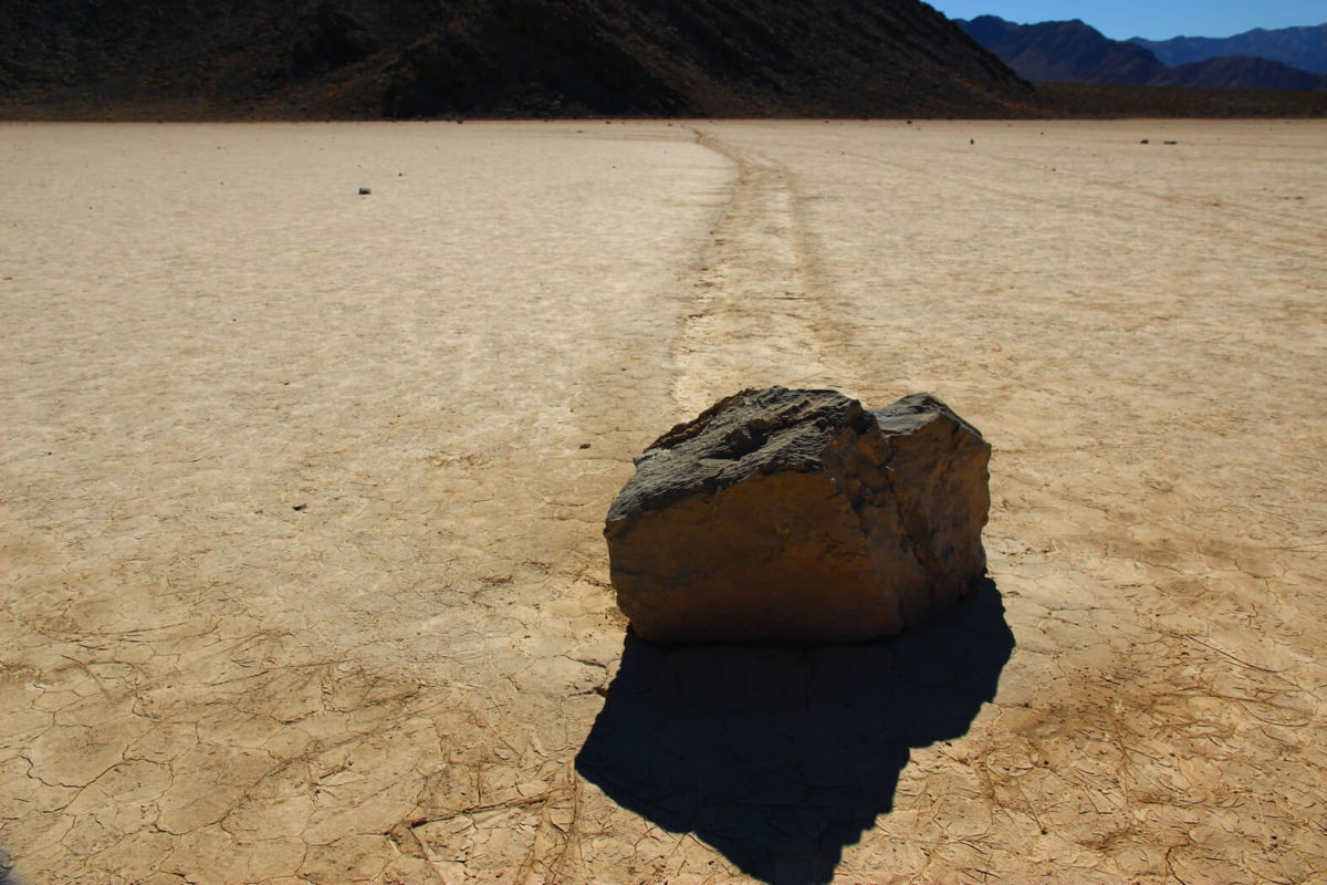
This rock leaves its trail across the Racetrack Playa. Death Valley National Park Photo.
The Playa is located 27 miles north of Ubehebe Crater on a fair dirt road. Depending on recent weather, the road can be quite rough and is not recommended for ordinary passenger cars. Check with the Rangers for current road conditions before heading out. Be considerate of others and do not walk on the play if it has rained recently. Footprints will be left in the soft mud that will last until the next big rain. Walk onto the play only during dry conditions.
‘Bird Watching’ in Death Valley’s Star Wars Canyon
Star Wars Canyon has become of the premier “bird watching” sites in Inyo County.
But the falcons, eagles and nighthawks flying through the canyon are not your standard feathered friends. As the canyon’s name implies, these “birds” and the rest of their flock are high tech fliers that roar thought the canyon at up to 500 miles per hour. These birds are combat jets and military aircraft that scream down and through this narrow canyon at the edge of Death Valley National Park in a blink of an eye. Or the blink of a camera shutter.
The canyon, officially named Rainbow Canyon is located just below Crowley Overlook off of Highway 190 on the west side of Death Valley National Park.
The overlook honors Father John Crowley, the “desert padre” who served and promoted Inyo County and Death Valley in the 1920s and ‘30s. That piece of history is not what draws the jet set folks to the overlook and the edge of the canyon. They come to wait sometimes hours and sometimes days to catch a glimpse and a photo of the military jets that race through the canyons on training missions.
The canyon is about 5,000 feet wide and about 5 miles long. That’s enough room for jet jockeys to put on a show. Sometimes the jets come screeching over the canyon rim and then “burn and turn” to give their fans a great scene. Sometimes the jets just blast through the desert air, focused on their mission.
The Air Force and Navy have been using Death Valley, Star Wars Canyon and much of southern Inyo County as a training area since World War II. The canyon is part of a restricted military airspace that is used for air-combat training, supersonic test flights and other training and flight operations.
The rise of social media has fueled the fame of Star Wars Canyon among aviation photographers and enthusiasts who enjoy the thrill of witnessing a modern flying machine moving and maneuvering at the speed of sound.
The region’s numerous military bases provide a steady flow of jets. The aircraft cruising Star Wars Canyon can come from Naval Weapons Station China Lake, Naval Air Station Lemoore, Edwards Air Force Base, Fresno Air National Guard Base, and Nevada’s Nellis Air Force Base. Planes from foreign allies also are known to use the canyon for training.
Patience and some luck top the list of requirements for those seeking a peek at the military jets. The Air Force and Navy do not provide any indication of when their planes will be in the canyon. It is not uncommon for plane-watchers to spend the day atop the canyon and not see a single plane. But then there are days when what seems to be a steady stream of jets come over, through and around.
Besides the Crowley Overlook, there are two other nearby viewing points. Plus, Panamint Springs Resort is at the end of the canyon, which makes it another spot for plane-spotting.
The Air Force acknowledges the canyon’s link to the iconic Star Wars movie franchise by calling the canyon “Jedi Transition.” But almost everyone else calls it Star Wars Canyon. The canyon is on the other side of Death Valley National Park from where scenes from the first Star Wars movie were shot that portray the Skywalker family’s desert planet, Tatoonie. Instead, there is another, more specific reason pilots and plane spotters link this particular canyon to the first Star Wars movie.
The most cited reference to the movie is the final sequence when Luke Skywalker and his fellow X-Wing pilots drop into the trench of the Empire’s Death Star and maneuver through the narrow “canyon.”
Regardless of what plane spotters and the military call the canyon, the sight of a war plane twisting and turning through Star Wars canyon is an extraordinary, otherworldly experience.
C-17 GROUP: This group of four C-17 Cargo jets swarm over Death Valley’s Star Wars Canyon. Photo by Jon Cassell/Panamint Springs Resort.
F-18 BELLY: An F-18 jet fighter pilot “turn and burns” through Death Valley’s Star Wars Canyon. Photo by Jon Cassell/Panamint Springs Resort.
JET DUNES: A fighter jet roars over the sand dunes after coming out of Death Valley’s Star Wars Canyon. Photo by Jon Cassell/Panamint Springs Resort.
JET MOUTAINS: A jet fighter on a training run with the mountains of Death Valley’s Star Wars Canyon in the background. Photo by Jon Cassell/Panamint Springs Resort.
Enjoy The Heat
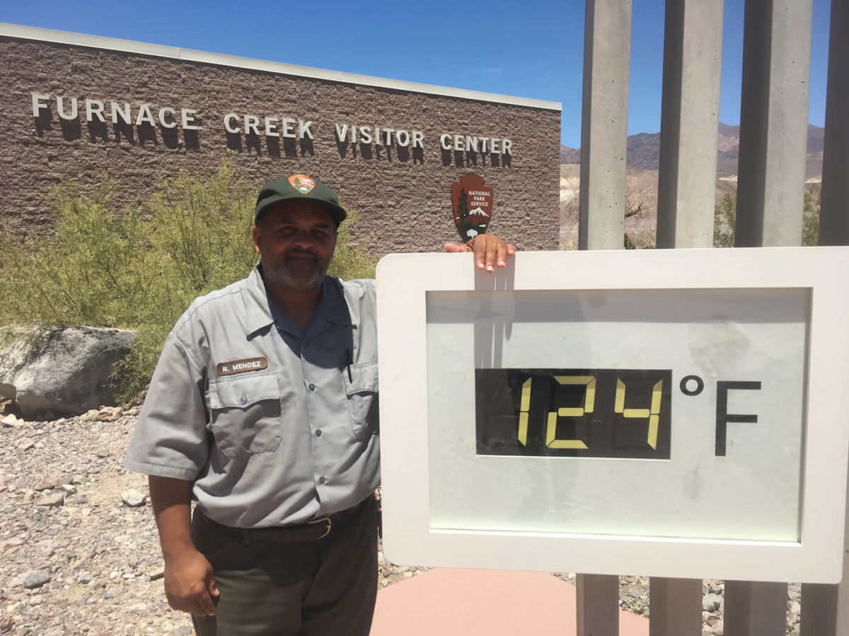
The temperature sign at the Furnace Creek Visitor Center confirms that “it’s hot in Death Valley.” Photo by Death Valley National Park.
Death Valley is the hottest place on Earth. In the summer months (May-September) temperatures average over 100°F (38°C), and often exceed 120°F (49°C). The world’s hottest temperature, 134 °F was recorded here in 1913.
Death Valley National Park, however, is perfectly safe to visit in the summer with some caution.
Drink and carry plenty of water: Carry with you and drink at least one gallon (4 liters) of water per day to replace loss from sweat, and drink more if you are active. Fluid and electroyte levels must be balanced, so have salty foods or sports drinks too.
Travel prepared to survive: Stay on paved roads in summer. If your car breaks down, stay with it until help comes. Carry extra drinking water in your car in case of emergency.
Watch for signs of trouble: If you feel dizzy, nauseous, or get a headache, get out of the sun immediately and drink water or sports drinks. Dampen clothing to lower body temperature. Be alert for symptoms in others. Heat illness can be severe and even deadly.
Most visitors in the summer choose mostly to tour by car. The main points remain open, but it is highly recommended to stay on paved roads and close to your vehicle.
Where to explore, recreate and be amazed in Death Valley and Inyo County
Inyo County is “The Other Side of California,” a vast expanse along the eastern edge of California that covers 10,000 square miles (16,000 sq. Km), an area greater than six U.S. states (VT, NH, NJ, CT, DL and RI).
Inyo County is a land of extremes. It claims the highest and lowest points in the 48-contiguous states, and the oldest trees in the world. You’ll find hot and cold, wet and dry, barren and lush, refined and common at different times and in different parts of the county.
The two most distinct aspects of Inyo County are Death Valley and the Eastern Sierra. Within these destinations are such natural wonders as Death Valley National Park, the Ancient Bristlecone Pine Forest, the Palisade Glacier, Mt. Whitney, Rock Creek Canyon, the High Sierra and a classic western landscape that has been seen in countless motion pictures. With six million acres (2.4 million hectares) of public land, Inyo County offers numerous opportunities to explore, recreate and be amazed.
Here is a brief rundown of what makes Inyo County so alluring:
It’s always a good idea to take water and friends when hiking in Death Valley. Death Valley National Park photo.
DEATH VALLEY
In 1849, a party of pioneers nearly perished while attempting to cross this desert valley. Upon being rescued, one turned and exclaimed, “Goodbye, Death Valley,” so naming it. Today, a million people say hello to Death Valley National Park, each year. The national park is the largest in the lower 48 states at 3.3 million acres (1.3 million hectares), and with the southeastern corner of Inyo County, comprises more than half the landmass of the county.
Death Valley attracts photographers, rock hounds, hikers and geologists to its fascinating and austere landscape.
Favorite sights include the nine-mile, looping Artist’s Drive with its many-colored rock formations. Popular trails pass through the Golden Canyon, Mosaic Canyon and Wildrose Peak trail. Each of these leads to amazing views and other-worldly formations. The Badwater Basin salt pan is the lowest point in North America — 282 ft/86 m — below sea level, and the highest point in the national park is Telescope Peak at 11,049 ft./3,315 m.
Badwater Basin, as seen from Dante’s View. Death Valley National Park photo.
Death Valley has more than its share of intimidating places: the Funeral Mountains, Rhyolite Ghost Town, Badwater, Stovepipe Wells, Salt Creek and Furnace Creek, among them. Yet, despite these notorious-sounding names, several species of wildlife inhabit the park and it’s so popular that for much of the year (late fall to late spring) available rooms and campsites are far and few between.
Park lodging centers at the Oasis (formerly Furnace Creek Resort) whose famous Inn was opened in 1927 by the Pacific Coast Borax Company of 20 Mule Team fame. The Furnace Creek Inn was meant to save the company’s failing railroad. As the value of mining faded, so did the railroad, but the Furnace Creek Inn thrived. It is today among the most highly sought and refined oasis to be found within the National Park System. Nearby The Ranch is a popular destination for families and RV campers. The park’s visitor center is located here and the Borax Museum displays artifacts, Borax wagons and other historic equipment from the park’s past.
Each season in Death Valley has its attraction. In winter, snowflakes tumble until they evaporate near the valley floor; near the end of winter, showy blooms of wildflowers appear; and in summer, temperatures often reach 120° F/49° C.
Stovepipe Wells – A motel, restaurant, pool, campground with RV sites and convenience store and gas station are located here. Old charcoal kilns and the ghost town of Leadfield are worth visiting.
Panamint Springs – They really mean it, when they say “Last Gas” at Panamint Springs at the national park’s western boundary. You’ll drive 30 miles before you find the next gas or water. Remember, you’re in Death Valley! Continue east on CA-190 to cross Towne’s Pass into Death Valley, south on CA-178 to Trona and west on CA-190 to Olancha and Lone Pine (CA-136).
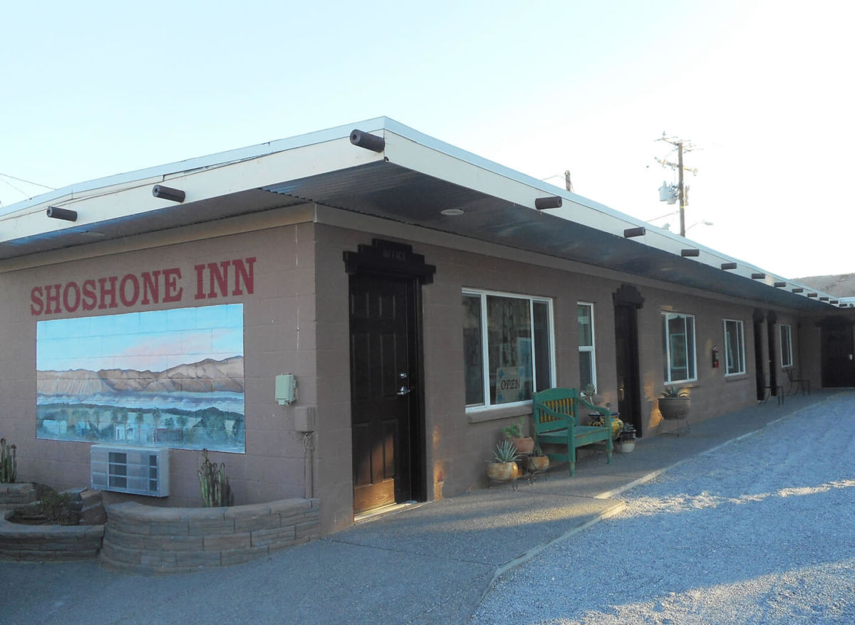
Shoshone – This desert town to the southeast of the national park was once a railroad center and rest area for local miners. It still serves as a service hub with food, gas, lodging, supplies and RV sites.
Tecopa – Named after Paiute-Shoshone Indian chief, Tecopa was a hard-rock mining camp in the late 1800s, though today, it is best known for its hot springs. Natural hot water is contained in separate bath houses for men and women, with RV sites and a small store. A surprising sight in this desert is Grimshaw Lake, a favorite of water skiers. Nearby marshes attract migratory birds and were a stopping point along the Old Spanish Trail, a National Historic Trail that passes through Tecopa. A treat five miles south of Tecopa is China Ranch where you can buy all kinds of treats made from dates… date shakes, date baked goods and take your date on a hike beside the federally recognized Wild and Scenic Armargosa River. At Dumont Dunes, 4-wheelers, dune buggies and dirt bikes get airborne in the dunes and take more terrestrial tours through scenic canyons.
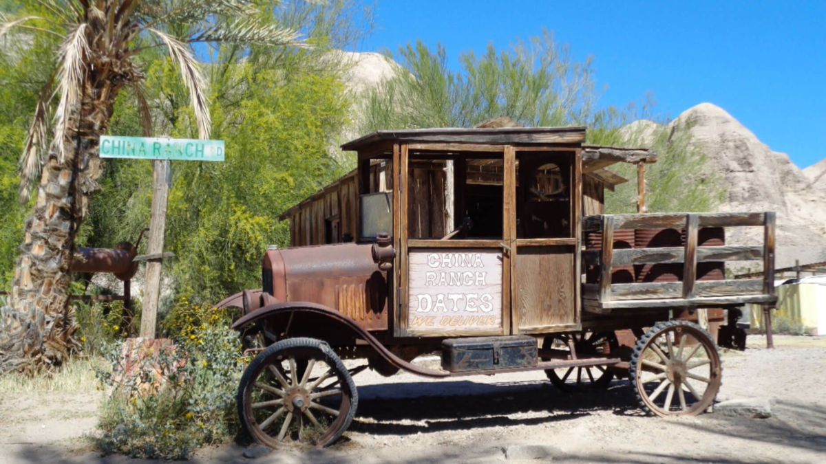
A hidden Oasis, the China Ranch Date Farm offers date nut bread, dates, date shakes and leads to the Amargosa River Canyon. Photo by Bill Neil.
OWENS VALLEY
One of the earliest American explorers described the Owens Valley as containing “ten thousand acres of fine grass.” Today, it is mostly arid. As told in Marc Reisner’s book, Cadillac Desert this once-fertile farmland, populated with fruit trees, was the victim of California’s Water Wars of the 1900s in which water rights to the Owens River were obtained by Los Angeles. Today, a third of LA’s water comes from the valley through the LA Aqueduct. Court rulings and actions by the Los Angeles Department of Water and Power have helped restore fish habitat along the river, making it again one of the finest fly fishing streams in the West.
Bishop – Calling itself a Small Town with a Big Backyard, Bishop is the hub for recreation of all kinds, from rock climbing and bouldering in the famed Alabama Hills, to fishing in the Owens River, Bishop Creek Canyon (also a fall colors hotspot) and various local lakes. Bishop is also the jumping off point for hikers seeking the solitude of the numerous high Sierra trails that wander into the unspoiled wilderness west of town, which also provides dramatic backdrop and sunsets that cannot be forgotten.
The most populated town in Inyo County, Bishop also has the most number of accommodations and services. Bishop began as a ranching town. Later, ranches evolved into pack stations with their sure-footed mules carrying the gear of fishermen and campers back into the Sierra. If any animal expresses the heart of Inyo County, it is the hard-working, intelligent, yet stubborn mule, which is honored annually during Bishop’s “Mule Days.”
Long before the ranchers arrived, Paiute Shoshone people lived here. Their reservation sits northwest of town and the Paiute Palace Casino adds excitement to a stay in Bishop. Many of Bishop’s visitors include a stop at the Owens Valley Paiute Shoshone Cultural Center and Museum to learn about the first inhabitants of the area and to enjoy experiencing one of the tribe’s cultural events.
Today, Bishop is the center of operations for the largest public utility in the nation, the Los Angeles Department of Water and Power, which provides water and power to the nation’s most populated city and provides access to the streams it manages for fishing. Southern California Edison also got its start in Bishop, and continues to operate hydroelectric power plants in the Bishop Creek Drainage, and its efforts to dam up streams and enlarge natural lakes created a world-class string of fishing holes.
Big Pine – This small town prides itself on being a gateway to the majestic Sierra Nevada and White Mountains. Drive east and you find the Ancient Bristlecone Pine Forest. Drive west and you find trailheads that lead to the Palisade Glacier and Eastern Sierra. Outfitters run horse packing trips to remote alpine lakes. Numerous fishing holes are found along Big Pine Creek and the Baker Ponds. The Owens River teems with trout, catfish and bass.
Independence – The county seat since 1866, Independence is the center of regional history with its historic courthouse; the Edwards House, oldest structure in the county; the Commander’s House, a century-old Victorian home; the Mary Austin home (she wrote Land of Little Rain); and the Eastern California Museum, with its extensive exhibits, artifacts, photographs, native plant garden and historic mining and farm equipment. Good fishing is found nearby at Independence Creek, the Onion Valley and along the Owens River. With a name like Independence, it’s understandable why the town has one of the best Independence Day parades with traditional early morning flag raising, pancake breakfast, fun run/walk, small-town parade, homemade ice cream and pie social, kids’ games, an arts and crafts show, deep-pit barbecue and sunset fireworks show.
Lone Pine – One of the most filmed and photographed landscapes in the county is found surrounding Lone Pine. West of town are the Alabama Hills, named by locals who were Southern sympathizers during the American Civil War. This collection of irregular, ruddy, windswept boulders backed by a horizon of Sierra peaks, has been the backdrop for about 400 Hollywood films from “Gunga Din,” to “Gladiator,” to “Rawhide,” to “Iron Man.” It’s where Roy Rogers first mounted Trigger, where Tom Mix rode to the rescue and where Robert Downey Jr. got blown up. Lone Pine has been seen in so many movies, that it has commemorated its fame by hosting the annual Lone Pine Film Festival. The Lone Pine Museum of Western Film History preserves the motion picture history of Inyo County with film memorabilia, cars, western carriages and an 84-seat theater.
Manzanar National Historic Site – During World War II, about 10,000 people of Japanese ancestry, about 60 percent being American citizens, were brought here to the Manzanar War Relocation Center as part of the “war hysteria” and racism that swept America after the bombing of Pearl Harbor. Manzanar was one of 10 Relocation Centers that eventually held about 120,000 people of all ages of Japanese descent for the duration of WW II. Finally, in the 1980s, the US government formally apologized to the internees for their imprisonment without charges. The site in now in the hands of the National Park Service. An interpretive center is located in the camp’s former auditorium, a number of replica barracks and buildings offer insights into camp life and a self-guided auto tours is offered.
EASTERN SIERRA
Mt. Whitney – On the east side of the Great Western Divide, Mt. Whitney stands 14,508 ft., the tallest mountain in the contiguous United States. Hikers reach the summit through Whitney Portal, 13 miles west of Lone Pine. It’s a 10.7 mile hike and requires planning, a wilderness permit and careful attention to advisories regarding the precautions of hiking at high altitudes, obtained within the Eastern Sierra InterAgency Visitor’s Center, south of Lone Pine.
Palisade Glacier – The southernmost glacier in the U.S. and the largest in the Sierra Nevada is located west of Big Pine and is visible from U.S. 395. The glacier sits at the base of Palisade Crest in the North Fork Basin. The scenery attracts hikers to trails that follow the ancient glacier.
Rock Creek Canyon – Between Bishop and Mammoth Lakes is picture-perfect Rock Creek Canyon. Rugged Eastern Sierra sawtooth peaks rise above emerald meadows, populated with fluttering aspens and cut my meandering clear streams.
Inyo National Forest and the John Muir Wilderness – For complete retreat, backpack or take a mule pack trip to the high country, to dozens upon dozens of remote glassine lakes with romantic names like Lake Helen of Troy, Elinore Lake, Moonlight Lake and the Treasure Lakes. You will understand why John Muir wrote, “Climb the mountains, and get their good tidings.” Few experiences are as emotionally satiating as being in the rarified air of the Eastern High Sierra in settings whose beauty defy description.
Sierra Bighorn Sheep – Three subspecies of bighorn sheep live in the United States. You can see two of them within minutes of one another in Inyo County, California. Sierra Bighorn can be seen in Eastern Sierra canyons. From U.S. 395, north of Bishop, follow Pine Creek Road through Round Valley. In the last couple of miles before the road ends, look up to the north to see the buff-colored coats of the Sierra Bighorn Sheep as they graze among pines and brush. You will be surprised how well they blend into the landscape and how difficult it is, at first, to see them. With practice, it becomes easier. There are no formal tours to see the bighorn, however the Bishop office of the California Department of Fish and Game can explain how best to see the elusive bighorns. Some tips: the Bighorn will not let you get closer than a couple of hundred yards, so bring powerful binoculars or a camera with a telephoto lens and enjoy seeing them from a distance.
WHITE MOUNTAINS
Ancient Bristlecone Forest – Thirty-six miles east of Big Pine in the White Mountains at elevations over 9,000 ft grow the oldest living trees. The oldest of them, Mehtuselah, is estimated to be nearly 4,800 years old. Several groves of the venerable trees can be seen. Exhibits at the visitor center at Schulman Grove describe the trees. From Big Pine, travel east on CA-168 to the Ancient Bristlecone Pine Forest Scenic Byway.
SOUTH COUNTY
Pearsonville – You’ve arrived in Inyo County, if traveling north on US 395 in a town often called the “Hub Cap Capitol of the World,” thanks to Lucy Pearson who for years collected a large collection of hubcaps and cataloging and storing each in a large warehouse. In Pearsonville, you’ll find gas, food, a towing service, wrecking yard and a ton of hubcaps!
Keeler – This was once the southern terminus of the Carson & Colorado Railroad. When service ended in the 1960s, most of Keeler’s residents moved away. The streets are mostly quiet and no services exist. However, if you have a 4WD vehicle, follow a dirt road east to Cerro Gordo, a ghost town with several well-maintained silver mine buildings and a small museum.
Olancha – This little ranching town has been a waystation since its inception in the 1860s. Cooling cottonwood trees and an inviting café attract travelers along US 395. Hikers and backpackers will often set off into the South Sierra Wilderness and onto the Pacific Crest Trail from nearby trailheads.
Darwin – Stop in Darwin and you won’t find any services, just a rich history, a hearty group of year-round residents and nearby Darwin Falls which begins as an underground spring that rises to the surface, spills over the falls and travels for a few hundred feet before disappearing again. Poke around Darwin and you’ll find old mines off dirt roads leading from CA-190.
